We’ve launched a new web portal! Visit findhistory.nd.gov to search our collections.
Due to a road closure, the Killdeer Mountain Battlefield State Historic Site
is temporarily closed.
This map was created in 1885 by G. W. and C. B. Colton and Company. George Woolworth and Charles B. Colton succeeded their father as the best mapmakers in the United States during the 19th century. This map measures 14 ½ by 12 ¾ inches. Source: SHSND 978.402 G11c 1885
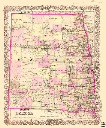
Colton’s map is dated before the territory was split in two at statehood. It is a largely political map in that it shows such political boundaries as the territorial border, county lines, and township lines. Sheridan County features Dogs Den Butte which has been present under other names on many earlier maps. Note the towns building approximately every 7 miles along the railroad line as designated by the railroad engineers.
Map Activity: Where are most of the towns located? Why? If you were planning to move to Dakota in 1885 which features on this map would you consider most appealing? Where are the Indian reservations? Compare this map to the 1884 Railroad Map. How do the maps differ?
Address:
612 East Boulevard Ave.
Bismarck, North Dakota 58505
Get Directions
Hours:
State Museum and Store: 8 a.m. - 5 p.m. M-F; Sat. & Sun. 10 a.m. - 5 p.m.
We are closed New Year's Day, Easter, Thanksgiving Day, and Christmas Day. We are closed at noon Christmas Eve if it falls on Mon.-Thurs. and are closed all day if it falls on Fri.-Sun.
State Archives: 8 a.m. - 4:30 p.m. M-F, except state holidays; 2nd Sat. of each month, 10 a.m. - 4:30 p.m. Appointments are recommended. To schedule an appointment, please contact us at 701.328.2091 or archives@nd.gov.
State Historical Society offices: 8 a.m. - 5 p.m. M-F, except state holidays.
Contact Us:
phone: 701.328.2666
email: history@nd.gov
Social Media:
See all social media accounts