We’ve launched a new web portal! Visit findhistory.nd.gov to search our collections.
Due to a road closure, the Killdeer Mountain Battlefield State Historic Site
is temporarily closed.
This map was drawn cartographers working for the New York map publisher, Asher and Adams, which was very active in publishing maps and atlases in the 1860s and 1870s. This map, published in 1873, measures 17 ½ inches by 23 ¾ inches. Source: SHSND 978.402 A825a 1873
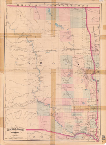
Asher and Adams compiled this map twelve years after Dakota Territory was officially established. At that time, settlement still clung to the eastern edge of the territory, with the exception of a small settlement at “the crossing” named Edwinton, soon to be renamed Bismarck.
Asher and Adams made railroad construction the focus of many of their maps. The Northern Pacific Railroad reached the Missouri River in June 1873. This 1873 map shows completed construction to Edwinton. The planned route to continue the Northern Pacific is shown with a plain line. Other railroads are concentrated in the southeastern corner of the territory near the capital city, Yankton. A couple of lines indicate planned routes for railroads that were not built.
The details on this map show the extent of the land survey in northern Dakota Territory in 1873, and a few counties are identified. All of the military posts are situated with the major exception of Fort Buford (along with the badlands and the western boundary of the state) which is located west of the western edge of this map. Topographical features can be seen, but unlike earlier maps were not emphasized by this company.
Map Activity: Compare this map to earlier maps including the Map of Ossiniboia. What features to they have in common. What is new in 1873?
Railroads had been crossing the continent for less than five years when this map was printed. Does this map indicate the significance of the railroad to settlement on the Great Plains?
Address:
612 East Boulevard Ave.
Bismarck, North Dakota 58505
Get Directions
Hours:
State Museum and Store: 8 a.m. - 5 p.m. M-F; Sat. & Sun. 10 a.m. - 5 p.m.
We are closed New Year's Day, Easter, Thanksgiving Day, and Christmas Day. We are closed at noon Christmas Eve if it falls on Mon.-Thurs. and are closed all day if it falls on Fri.-Sun.
State Archives: 8 a.m. - 4:30 p.m. M-F, except state holidays; 2nd Sat. of each month, 10 a.m. - 4:30 p.m. Appointments are recommended. To schedule an appointment, please contact us at 701.328.2091 or archives@nd.gov.
State Historical Society offices: 8 a.m. - 5 p.m. M-F, except state holidays.
Contact Us:
phone: 701.328.2666
email: history@nd.gov
Social Media:
See all social media accounts