


Surveying Land
Public lands in the West were surveyed and platted into one mile square grids, called sections, each containing 640 acres. Thirty-six sections, or a six-by-six- mile square became a township. With the Homestead Act of 1862, the government granted 160 acres, or a quarter of a section, to people who lived on and farmed a tract of land in the West.
Click here to view a PDF example of a Section-Township-Range map, courtesy of Brian Austin, State Historical Society of North Dakota.
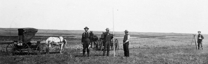
Survey party, Harrison collection, ca. 1890. SAHRL 0009-20
The surveyor is on the far right and the chain men and rodman are in the center.
A survey party consisted of a surveyor using a transit, a rodman using a rod, and two chain men using chains. Each chain is made up of 100 links, each measuring 7.92 inches. The total length of the chain is 66 feet, which is equivalent to 4 rods. An area 10 chains by 10 chains square contains 10 acres.