


1875 Dakota

Asher & Adams Dakota.
From Atlas by Asher & Adams,
New York, 1876-1877
Size 59x41cm, scale 20:1
SAHRL 978.3/1875/As35
This circa 1875 map shows the survey grid in the eastern part of North Dakota, and especially along the Pembina River to St. Joseph, encompassing the Métis settlements. In addition, the survey runs along the Northern Pacific Railroad track from Jamestown to Fargo and ending east of Edwinton. Counties in southern Dakota have been named after Presidents Lincoln and Grant.
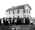
Territorial Capitol, Yankton, Dakota,
ca. 1880. SAHRL 389-53
When the territory was organized, Yankton, which had been founded in 1857, was chosen as the capitol. With a thriving business community and a bustling port, Yankton was in the most populated portion of the territory. It would remain the capital until the seat of government was moved to Bismarck in 1883.