We’ve launched a new web portal! Visit findhistory.nd.gov to search our collections.
Due to a road closure, the Killdeer Mountain Battlefield State Historic Site is temporarily closed.

Subscribe to SHSND podcasts
Located 1 1/2 miles northeast of Menoken, 10 miles east of Bismarck, ND.
Open year round.
Interpretive signs throughout the site provide a walking tour of the village.
No Rental Facilities
Free admission, donations welcome.
Early Archaeological Studies at Menoken Village State Historic Site
The fortification ditch and house depressions, as well as the site’s location away from the Missouri River, immediately caught the attention of archaeologists when the site was rediscovered in 1936. At that time, many people believed it was the location of the first recorded contact between Europeans and Native Americans in what is now North Dakota.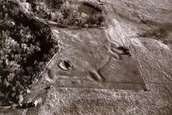
After its purchase by the State of North Dakota in 1937, archaeologists began work. Excavations focused on the palisade and west bastion, as well as on the pit house. These excavations exposed about 125 feet of the palisade. This defensive wall lay about ten feet inside the ditch and was made up of 700 to 800 posts, each six to eight inches in diameter. The ditch was originally about five feet deep and twenty feet wide.
This prominent fortification system that includes four loops or bastions seems quite large for the small area protected by the ditch. Only a small number of house or lodge depressions are visible at the site, and these are widely separated from one another, occurring both inside and outside the ditch. While fortified village sites are relatively common in North Dakota, they are typically much larger in area than Menoken Village and they often exhibit numerous lodge depressions closely spaced within the fortified area.
Geophysical Prospecting in Archaeology
Geophysics is the application of the methods of physics to the study of the earth to remotely investigate and define objects or materials in the subsurface without direct contact. Geophysical investigations do not disturb the soil and cultural features as do traditional excavations. Excavations, when combined with geophysical surveys, reveal information about prehistoric architecture and people’s use of space within a village.
Several houses within this village are marked by depressions on the present-day ground surface with large, open areas between them. When this site was surveyed using highly sensitive instruments that measure the physical properties of the area, additional burned, earth-covered structures were revealed in the open spaces.
Magnetometry measures changes in the magnetic properties that occur in the soil. 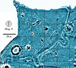 Magnetometry quantifies changes in soil magnetism. Burned houses, hearths, and iron artifacts are highly magnetic and readily sensed. The magnetometer map reveals the basic structure of Menoken Village. Notice the clearly visible ditch with its bastion loops, as well as several burned cultural features.
Resistivity methods use probes to pass an electrical current through the earth. Resistance to the current, caused by buried objects or soil variations is recorded. Though less distinct than the magnetic results, the mounded earth along the inside of the fortification ditch, some of the bastion loops, trails and previous excavations are clearly visible.
Address:
171st Street Northeast
Menoken, ND 58558
Get Directions
Hours:
Open year round.
Contact Us:
phone: 701.328.2666
email: history@nd.gov