We’ve launched a new web portal! Visit findhistory.nd.gov to search our collections.
Due to a road closure, the Killdeer Mountain Battlefield State Historic Site
is temporarily closed.

Subscribe to SHSND podcasts
Located 2 miles east of Little Yellowstone Park, near Enderlin, ND.
The access road to the site climbs a steep hill and access depends on weather and road conditions. There is a gravel parking lot at the top of the hill and a monument beside the mounds.
No Rental Facilities
Free admission, donations welcome.
No Related Links
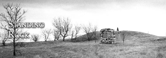
Perched on a high hill overlooking the Sheyenne River in Ransom County are a series of four interconnected burial mounds. Three of the mounds are circular, artificial hills in the shape of low cones. The fourth is a linear mound, which extends in a straight line. It begins west of the central mounds and runs east to the farthest conical mound. The site is named after a large boulder that stands on the top of the largest mound.
Burial mounds are human cemeteries that contain multiple graves and were built primarily during the middle of the Woodland period, dating from 100 B.C. to A.D. 600 (see Pulver Mounds). Some mounds continued to be used as a place of interment for more than a thousand years. A single conical mound can contain up to thirty-five individuals.
These burial grounds or cemeteries are sacred to many American Indians. In the state of North Dakota, mounds are classified as unmarked burial sites and are protected by law from disturbance.
Travelers used the Standing Rock mounds as a Sheyenne Valley landmark. The 1843 “Hydrographical Basin” map prepared by Joseph Nicollet identifies “Inyan Bosndata or Standing Rock.” According to linguist Dr. Robert Hollow, the correct spelling should be Íyá Bósdata, which means “Standing Rock” in Santee Sioux. Nicollet and John C. Frémont camped within sight of the site on Monday, August 12, 1839 (see Lake Jessie for more information about the Nicollet and Frémont expedition). From March 1881 to July 1884, the local post office was called “Standingrock,” because the Post Office Department refused to accept post office names of more than one word.
The site is two miles east of Little Yellowstone Park, near Enderlin, Ransom County. The access road to the site climbs a steep hill and access depends on weather and road conditions. There is a gravel parking lot at the top of the hill. A monument beside the mounds gives a brief description of the significance of this prehistoric cemetery.
SHSND Address:
612 East Boulevard Ave.
Bismarck, North Dakota 58505
Get Directions
SHSND Hours:
Museum Store: 8am - 5pm M-F; Sat. & Sun. 10am - 5pm.
State Archives: 8am - 4:30pm., M-F, except state holidays, and 2nd Sat. of each month, 10am - 4:30 pm.
State Historical Society offices: 8am - 5pm M-F, except state holidays.
Contact SHSND:
phone: 701.328.2666
email: history@nd.gov