We’ve launched a new web portal! Visit findhistory.nd.gov to search our collections.
Due to a road closure, the Killdeer Mountain Battlefield State Historic Site
is temporarily closed.

Subscribe to SHSND podcasts
Located 3 miles south of Chaffee, ND.
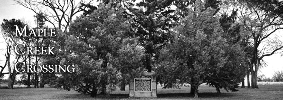
Although no visitor services are available and the ford is not visible from the site, the state property is attractive, well tended, and accessible year-round. There is a marker on a masonry base made of stone from the first North Dakota Capitol
No Rental Facilities
Free admission, donations welcome.
No Related Links
Maple Creek Crossing State Historic Site recognizes a stream crossing important to travel in the days before bridges. With its gently sloping banks and firm bottom, this ford across the Maple River was a landmark in the early days of the exploration and settlement of Dakota Territory. Located three miles south of Chaffee, Cass County, the .38 acre historic site lies immediately east of St. Peter’s Lutheran Church on a grassy terrace near a bend in the river. The actual stream crossing is approximately one-half mile northwest of the site marker.
Euro-American use of the crossing may have occurred as early as 1822, when discouraged members of the Selkirk Colonies moved from the Pembina area to the Mississippi River near Fort Snelling (St. Paul, Minnesota). They followed an early fur trade trail along the western edge of the ancient Lake Agassiz shore line that crossed the Maple River.
By 1843 oxcart brigades of Norman Kittson and “Jolly” Joe Rolette were fording the Maple River on an established trade route between St. Paul and the Canadian border settlements of Pembina and St. Joseph (see Walhalla). Six years later, Major Samuel Woods led a military reconnaissance expedition across the ford on a mission to “show the flag” to Métis settlers and recalcitrant Indians in the Pembina area, while gathering information about the region.
In 1851 Alexander Ramsey, governor of Minnesota Territory, used the crossing on a journey to Pembina. He was negotiating a treaty for the United States to buy five million acres of Chippewa land. The sale would have opened the Red River Valley area to Euro-American settlement. Although the Chippewa agreed, the United States Senate refused to ratify the treaty.
General Isaac I. Stevens, recently appointed governor of the newly created Washington Territory, crossed the river in 1853 while headed to the Pacific Northwest to assume his new duties. The journey also incorporated military exploration of the region to find a practical route for a transcontinental railroad. Nine years later, Captain James L. Fisk led a party of immigrants across the ford en route to newly discovered gold fields in Montana.
In 1863 the Sibley expedition returned to Minnesota via the ford (see Sibley and Sully Expeditions of 1863). Camp Ambler, the Sibley army’s bivouac on August 17, 1863, was located southeast of the Maple Creek marker. By the time the troops reached the stream, they were nearly exhausted. The expedition’s surgeons reported that 433 men were affected by the summer heat. Of these, 150 were so sick they had to be transported by ambulance for at least part of the day’s march. The men rested and recuperated at Camp Ambler until leaving early in the morning of August 19.
A sod structure, located a half mile to the southeast, served as a shelter for mail carriers, freighters, and others traveling the Fort Abercrombie-Fort Ransom-Fort Totten trails during the 1860s and 1870s. A wood-frame store and inn replaced the sod building, operated from 1879 until 1883 by James N. Watson.
The modern-day Maple Creek Crossing State Historic Site displays a marker on a masonry base made of stone from the first North Dakota Capitol, which burned on December 28, 1930. Although no visitor services are available and the ford is not visible from the site, the state property is attractive, well tended, and accessible year-round.
SHSND Address:
612 East Boulevard Ave.
Bismarck, North Dakota 58505
Get Directions
SHSND Hours:
Museum Store: 8am - 5pm M-F; Sat. & Sun. 10am - 5pm.
State Archives: 8am - 4:30pm., M-F, except state holidays, and 2nd Sat. of each month, 10am - 4:30 pm.
State Historical Society offices: 8am - 5pm M-F, except state holidays.
Contact SHSND:
phone: 701.328.2666
email: history@nd.gov