We’ve launched a new web portal! Visit findhistory.nd.gov to search our collections.
Due to a road closure, the Killdeer Mountain Battlefield State Historic Site is temporarily closed.
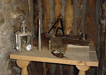
The Lewis and Clark expedition utilized a number of navigational tools that were common in their day. Ascertaining latitude and longitude was accomplished using a sextant, and octant, a chronometer, and several types of artificial horizons. In addition to these instruments, the expedition carried a circumferentor, or surveying compass. The latter was utilized to find the difference between magnetic north and true north. While imperfect by the standards of today’s global positioning systems, they did allow the Corps of Discovery enough certainty to have a relatively good idea where they were at any given time. Nonetheless, a mistake of two degrees in calculations could mean an error of up to one hundred miles. Since they were in unknown parts anyway, this was not to provide a problem that could not be solved.
Address:
612 East Boulevard Ave.
Bismarck, North Dakota 58505
Get Directions
Hours:
State Museum and Store: 8 a.m. - 5 p.m. M-F; Sat. & Sun. 10 a.m. - 5 p.m.
We are closed New Year's Day, Easter, Thanksgiving Day, and Christmas Day. We are closed at noon Christmas Eve if it falls on Mon.-Thurs. and are closed all day if it falls on Fri.-Sun.
State Archives: 8 a.m. - 4:30 p.m. M-F, except state holidays; 2nd Sat. of each month, 10 a.m. - 4:30 p.m. Appointments are recommended. To schedule an appointment, please contact us at 701.328.2091 or archives@nd.gov.
State Historical Society offices: 8 a.m. - 5 p.m. M-F, except state holidays.
Contact Us:
phone: 701.328.2666
email: history@nd.gov
Social Media:
See all social media accounts