We’ve launched a new web portal! Visit findhistory.nd.gov to search our collections.
Due to a road closure, the Killdeer Mountain Battlefield State Historic Site
is temporarily closed.
This is the official statehood map of 1889. It measures 17 ½ inches by 23 inches.
Source: SHSND Immigration 978.4031 N864o 1989
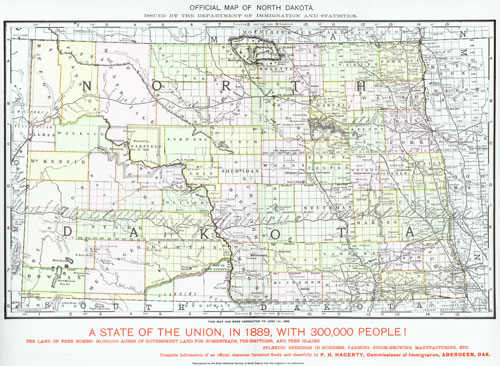
North Dakota gained its final boundaries in 1889 when it entered the Union. It had undergone several changes during the early territorial period. At first, what we know as eastern North Dakota was part of Minnesota Territory. When Minnesota became a state in 1858, its western portions were removed at the Red River. This area became part of Dakota Territory in 1861 which stretched west through most of modern day Montana and part of northern Wyoming. In 1863, Congress created Idaho Territory. This was another sprawling territory with its eastern border on the 104th meridian – North Dakota’s modern western boundary. Congress chose the 104th meridian because in creating new territories and states, Congress wanted to make them as equal in size as possible. Therefore, North and South Dakota, Wyoming, Colorado, Washington, and Oregon are similar in size, each having about 7 degrees of longitude in width.
The southern border was established when the territory split into two states and the reasoning was similar. The column of states in the Great Plains formed by Kansas, Nebraska, South Dakota, and North Dakota were divided equally, each having 3 degrees of latitude. Only one of North Dakota’s boundary lines was based on a natural feature, the Red River of the North; the other boundaries were drawn by surveyor’s lines along the meridians.
Map Activity: This map was published by the Department of Immigration and Statistics. What kind of information is available on this map? If it was distributed to people in Europe who were considering immigrating to North Dakota, what would they find appealing or useful? Have the counties changed in size, shape, or name since 1889?
Address:
612 East Boulevard Ave.
Bismarck, North Dakota 58505
Get Directions
Hours:
State Museum and Store: 8 a.m. - 5 p.m. M-F; Sat. & Sun. 10 a.m. - 5 p.m.
We are closed New Year's Day, Easter, Thanksgiving Day, and Christmas Day. We are closed at noon Christmas Eve if it falls on Mon.-Thurs. and are closed all day if it falls on Fri.-Sun.
State Archives: 8 a.m. - 4:30 p.m. M-F, except state holidays; 2nd Sat. of each month, 10 a.m. - 4:30 p.m. Appointments are recommended. To schedule an appointment, please contact us at 701.328.2091 or archives@nd.gov.
State Historical Society offices: 8 a.m. - 5 p.m. M-F, except state holidays.
Contact Us:
phone: 701.328.2666
email: history@nd.gov
Social Media:
See all social media accounts