We’ve launched a new web portal! Visit findhistory.nd.gov to search our collections.
Due to a road closure, the Killdeer Mountain Battlefield State Historic Site is temporarily closed.

Subscribe to SHSND podcasts
Located one-half mile west of Verendrye, ND.
A granite globe atop a rectangular granite base, the site is enclosed by a barbed wire fence.
No Rental Facilities
Free admission, donations welcome.
No Related Links
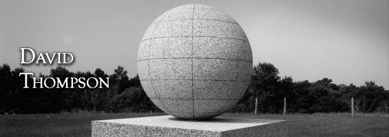
David Thompson, explorer, fur trader, and the first European to explore the entire length of the Columbia River, was called by a contemporary “the greatest geographer of his day in British America.” To honor his accomplishments as a geographer and astronomer, the David Thompson State Historic Site is marked by a granite globe atop a rectangular granite base, northeast of Velva, McHenry County.
David Thompson was born in Westminster, England, on April 30, 1770. He was educated at London’s Grey Coat School, a charitable institution. When he was fourteen years old, he left school and became an apprentice to the Hudson’s Bay Company to learn clerking, surveying, and hunting. In 1797, after finishing his apprenticeship, he joined the Northwest Company, a formidable fur trade competitor of his former employer.
As part of his first trading assignment, an attempt to establish a trading alliance with the Mandan and Hidatsa Indians living in a group of villages at the mouth of the Knife River (currently Knife River Indian Villages National Historic Site), Thompson was entrusted with the task of mapping the Northwest Company’s posts and determining their relationship to the American border. Although the border was understood to run westward along the 49th parallel to the Rocky Mountains, it was still in dispute. Thompson passed near the historic site while on this assignment, leaving the Souris River a short distance west of the confluence of the Wintering River with the Souris on December 23, 1797. Thompson’s surveys and observations from this expedition led to the first reliable map of the region from the west bend of the Souris River to the western shore of Lake Superior, a map used by Lewis and Clark during their expedition across North America.
Thompson continued his explorations and observations for another fifteen years, and the exploration of the Columbia River was his most famous accomplishment. In 1812 Thompson retired from active trading and exploration. He settled in Terrebonne, Quebec, where he finished his great map of the Northwest. For ten years Thompson worked for the International Boundary Commission and during his last years, he completed the narrative of his experiences. He and his Scotch-Cree wife, Charlotte, raised thirteen children. David Thompson died February 10, 1857.
The David Thompson State Historic Site is enclosed by a barbed wire fence and overlooks the beautiful Souris River Valley. The Great Northern Railroad donated the land to the state and commissioned and erected the monument, which was dedicated on July 17, 1925. The pedestal under the globe bears the following inscription:
1770 DAVID THOMPSON 1857
Geographer and Astronomer
Passed near here in 1797 and 1798 on a scientific and trading expedition.
He made the first map of the country which is now North Dakota and
achieved many noteworthy discoveries in the Northwest.
SHSND Address:
612 East Boulevard Ave.
Bismarck, North Dakota 58505
Get Directions
SHSND Hours:
Museum Store: 8am - 5pm M-F; Sat. & Sun. 10am - 5pm.
State Archives: 8am - 4:30pm., M-F, except state holidays, and 2nd Sat. of each month, 10am - 4:30 pm.
State Historical Society offices: 8am - 5pm M-F, except state holidays.
Contact SHSND:
phone: 701.328.2666
email: history@nd.gov